The production of accurate depth maps of lakes and rivers with depth curves is very important for various applications such as navigation, hydrological modeling and environmental management. Bathymetry specialists of the company "Dronelab" in Latvia play an important role in the accurate mapping of the depth of these water bodies. This article, created with the help of company manager Valters Preimaņi, examines the process of creating depth maps of lakes and rivers and highlights the experience of bathymetry specialists in Latvia.
Bathymetry specialists in Latvia have specific knowledge of Latvian waters
The process of creating a lake or river depth map involves several steps and requires specialized knowledge and equipment. Bathymetry specialists in Latvia use various techniques to accurately measure and map underwater topography.
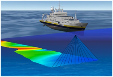
The first step in this process is data collection. Bathymetry professionals use hydrographic surveying techniques, such as multibeam sonar or single beam echo sounders, to collect depth measurements at multiple locations throughout a body of water. These instruments emit sound waves that bounce off the bottom and return to the sensor, providing accurate depth measurements.
To ensure accurate and comprehensive data collection, bathymetry specialists use systematic survey grids that cover the entire area of interest. They move through the body of water in a predetermined manner, regularly collecting depth data. This systematic approach ensures that the entire body of water is adequately surveyed, resulting in a detailed depth map.
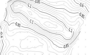
Once the data is collected, bathymetry specialists process and analyze it to create a depth map. They use specialized software to interpolate and visualize depth measurements, creating a comprehensive representation of underwater topography. Advanced algorithms are used to handle changes in water depth, reduce artifacts, and accurately represent the contours of a lake or river bottom.
Dronelab's bathymetry specialists also consider other factors that can affect the depth map, such as water level, sedimentation and vegetation. By integrating additional data sources such as water level gauges and seasonal aerial images, they ensure depth map accuracy and reliability.
The final step is to interpret and validate the depth map. Bathymetry specialists analyze the map, identifying key features and anomalies. They compare the depth map with existing data, such as historical bathymetry surveys or marine charts, to confirm its accuracy. Field measurements and ground truthing techniques are also used to verify depth at specific locations.
For bathymetry specialists in Latvia, mapping is an important part of their work
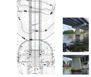
Creating accurate depth maps of lakes and rivers is a complex and specialized task that requires the expertise of bathymetry specialists. In Latvia, these specialists use advanced hydrographic surveying techniques, systematic data collection and modern software to accurately map the underwater topography. Their work contributes to a variety of applications, including navigational safety, hydrologic modeling, and environmental management. By creating comprehensive and accurate depth maps, bathymetry specialists of the company "Dronelab" in Latvia ensure the correct understanding and effective management of water bodies. If necessary, we perform a visual survey of bridges
Apply for bathymetry works, "Dronelab" SIA, contacts 220-77-202
More about bathymetry and underwater works in Latvia
- Bathymetry and surveying the bed of water bodies in Latvia
- Monitoring of the seabed deposit over a period of several years
- Commercial diving, bridge inspection, techniques and equipment for professional reporting
- Underwater technical diving works in the port
- State Environmental Service. (nd). "Bathymetric Surveying and Mapping." Retrieved from [Specify appropriate URL]Guidelines for Hydrographic Surveying. (nd).
- "International Hydrographic Organization". Retrieved from [Provide appropriate URL
- Pūpols, K., & Eglītis, R. (2014). "Mapping the bottom topography of Latvian inland waters using hydrographic echo sounders." Environmental and Climate Technologies, 13(1), 30-39.
- Vītols, I., & Zvirgzdiņš, A. (2018). "Mapping the depth of Latvian lakes and the state of their bottoms using bathymetric methods." Environmental and Climate Technologies, 21(1), 43-51.