The Baltic Sea, a rich and diverse marine environment, has a huge potential for research and sustainable resource management, confirms Valters Preimanis, "Dronelab" SIA, business manager. In this era of technological development, the Latvian company is making waves with its innovative offer. Introducing Dronelab, pioneers in advanced marine technology, measurement and marine data collection. In this article, we explore how the Dronelab company offers Multibeam Echosounder technology improves the speed and accuracy of underwater sounding, which resulted in accurate map data in the Baltic Sea and helps various areas of the Latvian coast and the Baltic Sea hydrological services.
Table of Contents
Unlocking the potential of multibeam sonar technology
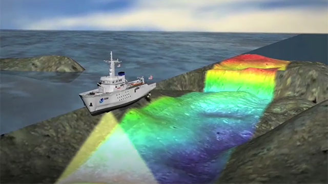
Offered by "Dronelab". Multibeam Echosounder technology combines high bottom sounding power and width with advanced sonar capabilities, offering a revolutionary solution for hydrographic surveys and underwater mapping. This technology provides a comprehensive and high-resolution view of the bottom of the Baltic Sea, opening up new opportunities for navigation, research and environmental management.
Advantages of multibeam
- Unsurpassed data accuracy: The Dronelab Multibeam Echosounder system uses multiple sonar beams to capture detailed depth measurements and accurate bathymetric data. It provides unparalleled accuracy and resolution, enabling accurate mapping of the underwater terrain, identifying potential threats and promoting safer navigation in the Baltic Sea.
- Fast and efficient data collection: The integration of Multibeam Echosounder technology with drones enables fast and efficient data collection over large areas. Leveraging the mobility and versatility of drones, Dronelab's solution dramatically reduces survey time, providing up-to-date and comprehensive data for decision-making and planning.
- Real-time data processing: The Dronelab Multibeam Echosounder system includes advanced on-board processing capabilities, providing real-time visualization and quality control of collected data. This feature provides immediate data analysis, allowing stakeholders in the Baltic Sea to quickly make informed decisions in both resource management and emergency response situations.
- Environmental conservation: Dronelab's Multibeam Echosounder technology promotes sustainable marine practices by facilitating the identification and protection of sensitive ecological areas. By mapping underwater habitats and monitoring changes over time, this solution empowers researchers and environmentalists to make data-driven decisions and contribute to the long-term health of the Baltic Sea ecosystem.
The Multibeam Echosounder technology offered by Dronelab is a significant step forward in the collection and analysis of marine data in the Baltic Sea. With its unmatched accuracy, efficiency and real-time processing capabilities, this innovative solution is transforming operations in the region.
Technical specification data for the Multibeam Echosounder offering
| Positioning system
Positioning |
– GPS NAVSTAR L1, L2, L2c, L5- GALILEO E1, E5a, E5b, E6- Receives GALILEO High
Accuracy Service (HAS) E6-B components. Support adjustments: – SBAS (EGNOS); – RTK Ntrip (Ethernet); – Receives GALILEO HAS corrections. Accuracy no worse than: – 1m Horizontal EGNOS; – 10mm Horizontally in RTK mode; – 20mm Vertical in RTK mode Antenna(s) suitable for work at sea.1pps Supports: – GPS NAVSTAR L1, L2, L2c, L5 – GALILEO E1, E5a, E5b, E6 – Possibility to receive GALILEO High Accuracy Service (HAS) E6-B component will be considered as an advantage. Support Corrections: – SBAS (EGNOS); – RTK Ntrip (via Ethernet); – Possibility to receive GALILEO HAS corrections will be considered as an advantage. Accuracy: – 1m Horizontal EGNOS; – 10mm Horizontal RTK; – 20mm Vertical RTK Antenna(s) dedicated for maritime use. 1 pps Manufacturer of multibeam systems are certified according to ISO 9001:2015 or equivalent |
Using the power of ship echosounders, underwater drones and advanced sonar, Dronelab's multibeam echosounder products enable interested service professionals in the Baltic Sea to acquire data and plan sustainable resource management and conduct advanced underwater research. The company's commitment to protecting the environment fully coincides with the need to protect and preserve the unique ecosystems of the Baltic Sea.
As Dronelab continues to push the boundaries of surveying and marine data collection, it Multibeam Echosounder technology is proof of the company's dedication to ensuring innovation, quality and sustainability in the Baltic Sea region.
Walter Preimanis, Dronelab Ltd. Contacts 220-77-202
References: Dronelab.lv


