Bathymetry is the process of measuring and mapping the underwater features of oceans, rivers, lakes and other bodies of water. Surveying the bed of water bodies is a critical task that requires advanced technology and expertise.
In recent years, the latest multibeam echo sounder technologies and underwater drones equipped with bathymetry equipment have revolutionized the field of bathymetry and surveying. Among the leading companies in this field is the Latvian company, "Dronelab" SIA, whose underwater measurement specialists are known for their quality work. In this article, we will examine why the bathymetry data obtained by Latvian company specialists is the best choice for professional surveying work.
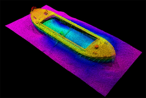
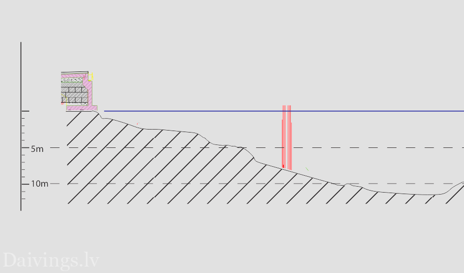
Our clients' underwater mapping requirements include a variety of tasks - surveying in rivers, lakes or harbors. Carrying out depth measurements with a high-precision multi-beam echo sounder depicting the surface of the bed (the resolution is not less than 0.1 m, and the number of emitted beam pulses is not less than 500 units),
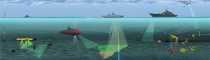
Table of Contents
Importance of bathymetry in Latvia
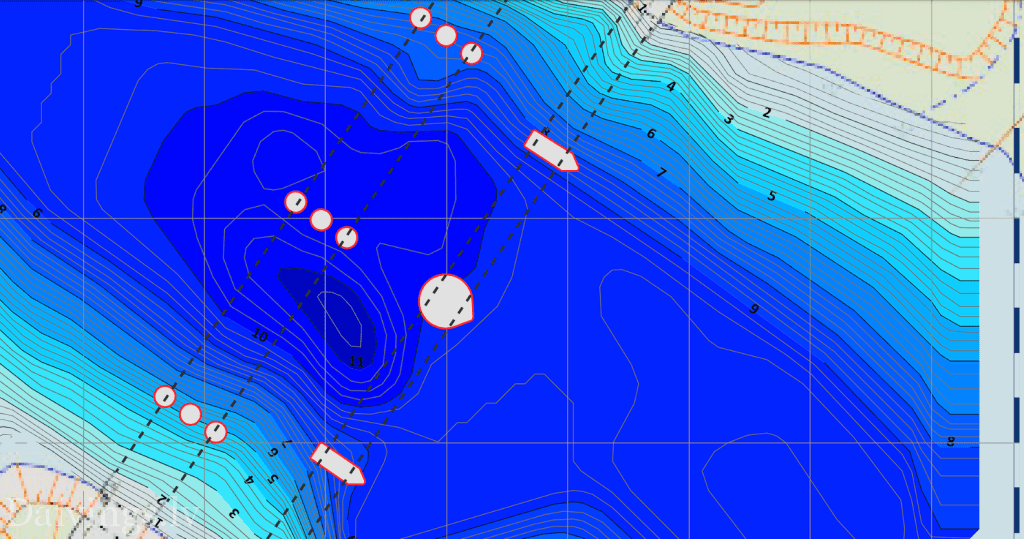
Bathymetry is crucial for a variety of applications, including coastal zone management, safety of navigation, infrastructure development and environmental monitoring. Bathymetric data is used to create accurate and detailed maps of underwater features such as depth contours, seafloor topography and substrate composition. This information is critical to understanding the geomorphology of the aquatic environment, predicting water circulation patterns, and identifying potential hazards.
Why choose Latvian company Dronelab for bathymetry data acquisition?
Dronelab SIA is a leading provider of technology-based surveying and mapping services using the latest acoustic underwater sounding technologies. Among the leading Latvian companies in the field of bathymetry, underwater measurements, there is a group of specialists, "Dronelab" SIA, whose underwater measurement specialists are known for their prompt and high-quality work, both in shallow and deep reservoirs. Engineers, hydrography and hydrology specialists engaged by the company are experts in the use of underwater surveying and other modern technologies for the collection and processing of bathymetric data. Here are some of the reasons why Dronelab is the best choice for professional surveying work:
Latest technologies: The company uses advanced equipment such as multibeam sonar systems to collect high-resolution bathymetric data. These systems are able to produce accurate maps of the seabed even in difficult conditions.
Big experience: underwater bathymetry specialists have extensive experience in bathymetric surveying and mapping. They are trained to work with sophisticated equipment, interpret data and create detailed maps of underwater features.
Efficiency: Dronelab's state-of-the-art surveying services are highly efficient. They can quickly collect large amounts of data and process it in real time, allowing customers to make informed decisions in a timely manner.
Safety: Dronelab prioritizes safety in all its operations. Their technicians are trained to work with the equipment in accordance with all relevant regulations and use a range of safety measures to ensure their work runs without incident.

In bathymetry data acquisition, the main components are always human
It must be said that bathymetry is a critical field that requires advanced technology and expertise. Dronelab is a leading provider of underwater surveying and mapping services and their experts are the best choice for professional bathymetry work. They use state-of-the-art equipment, have extensive experience, are highly efficient and prioritize safety. If you need accurate and detailed maps of underwater objects, Dronelab is the company to choose.
Professional bathymetry hardware and software tools are essential to accurately measure the depth and topography of the underwater environment. There are several brands that offer high quality hardware and software solutions for bathymetry surveying, mapping and analysis.
Top bathymetry hardware brands
- Kongsberg: Kongsberg is a leading provider of underwater mapping systems, including multibeam echo sounders and side scan sonar.
- Teledyne Marine: Teledyne Marine offers a wide range of hydrographic surveying tools, including single-beam and multi-beam sounders, as well as side-scan sonar and bottom profilers.
- R2Sonic: R2Sonic manufactures high resolution multibeam sounders for bathymetry surveying.
- Sonardyne: Sonardyne manufactures advanced acoustic positioning and communications technologies for the marine industry, including bathymetry equipment.
- Valeport: Valeport specializes in the design and manufacture of underwater sensors, including sound speed profilers and wave recorders.
Top Bathymetry Software Brands
- HYPACK: HYPACK is a comprehensive hydrographic survey software package that includes tools for data acquisition, processing and analysis.
- KING: CARIS offers a range of bathymetry software solutions for hydrographic data processing and analysis, including the HIPS and SIPS suite.
- QPS: QPS provides software for the acquisition, processing and analysis of marine geospatial data, including bathymetry.
- Fledermaus: Fledermaus is a 3D visualization and analysis software for hydrographic data processing and analysis.
- Trimble Marine: Trimble Marine provides software solutions for marine surveying and navigation, including bathymetry mapping and analysis.
Choosing the right bathymetry hardware and software tools can be a difficult task. Factors such as accuracy, resolution, data processing capabilities and ease of use are important to consider. It is recommended that you consult a professional bathymetry specialist to determine the most suitable instruments for your specific needs.
References and articles on bathymetry:
- "Bathymetry: The Art of Measuring the Depth of Water." National Oceanic and Atmospheric Administration, 2019.
- "Dronelab - Services." Dronelab, 2021.
- "Multibeam Sonar Systems." Teledyne Marine, 2021.
- "Bathymetry: Mapping the Sea Floor." Schmidt Ocean Institute, 2021.
- "The Role of Bathymetry in Coastal Zone Management." International Hydrographic Organization, 2018.
Finally, about bathymetry
Thank you for reading our article on bathymetry to the end. Among the leading Latvian companies in the field of bathymetry and underwater measurements is a local company, "Dronelab" SIA, whose underwater measurement specialists are known for their prompt and high-quality work.
"Why did our underwater drone take a bath?"
“To better understand bathymetry, of course!”